- トップページ >
- 施設情報・詳細情報一覧 >
- 旅館大村屋(伊能忠敬本陣)跡ほか S...
旅館大村屋(伊能忠敬本陣)跡ほか Site of Ryokan Oomuraya (lodging where Tadataka Ino stayed), etc.
In the mid-Edo period and afterwards, Ryokan Oomuraya enjoyed the premium location because it was conveniently located just in front of the hot spring bath operated by the Domain and it offered a great view of the Ureshino River and the steam rising up from the hot spring inside the river.
Nampo Ota (1749-1823), a gesaku writer and poet, wrote his songs from here, and the team of Tadataka Ino (1745-1818), who made the first maps based on actual measurements in Japan, also stayed here.
-Remainder of Matoba Watashi
During the Edo period, the only streets passing Ureshino-shuku were the Nagasaki Kaido, which ran across the post town in a north-south direction, and another, which intersected the former at a right angle and connected Zuikoji Temple and the hot spring bath operated by the Domain.
The Ureshino River did not have any bridge connecting the east and west shores, and the only way to cross it to the east shore was to go over the steppingstones at Matoba Watashi.
These stones remained until slightly after 1887, even after the bridge was built.
(Near present Oomuraya)
基本情報
- 住所
- 佐賀県嬉野市嬉野町大字下宿乙
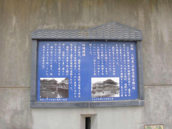
江戸時代中期以後の旅館大村屋は、藩営浴場のすぐ前にあり入浴には便利、嬉野川に面して景色もよく、川中の湯煙もよく見える最良の場所であった。
戯作者で文人の大田南畝(1749~1823)もここで作詞をし、日本で初めて実測による地図を作った伊能忠敬(1745~1818)一行もここを本陣とした。
・的場渡跡
江戸時代、嬉野宿近くの道路は宿場を南北に貫通する長崎街道と、これに直角に交わる瑞光寺~藩営浴場間の道路だけだった。
嬉野川の東西を結ぶ橋は無く、宿場から東へ渡るには的場渡の飛び石を渡る方法しかなかった。
橋が架けられた後も、明治20年代まで残っていた。
(現在の大村屋付近)
360度パノラマビュー
マウスでドラッグまたは、タッチで操作してください。
GoogleMap


- 一般社団法人 嬉野温泉観光協会
- 嬉野市嬉野町大字下宿乙2202-55
TEL 0954-43-0137
定休日 木曜日
営業時間 9:00~18:00
info@spa-u.net - 嬉野温泉旅館組合(協会内)
TEL 0954-42-0240
定休日 木曜日
営業時間 9:00~18:00
bihada@spa-u.net - 嬉野市役所 観光商工課
嬉野市嬉野町大字下宿乙1185番地
TEL 0954-42-3310
kankou@city.ureshino.lg.jp
